Thank you for supporting this site ❤️
Make a donation
Make a donation
Gear up for your next adventure:
As an Amazon Associate, this site earns from qualifying purchases at no extra cost to you.
Deer Reserve State Forest - Mount Mcconnel
Interactive trail map
Thank you for supporting this site ❤️
Make a donation
Make a donation
Gear up for your next adventure:
As an Amazon Associate, this site earns from qualifying purchases at no extra cost to you.
Trail profile
- Distance: 25.1 mi
- Elevation gain: 3,428 ft
- Maximum elevation: 1,585 ft
- Elevation loss: 3,428 ft
- Minimum elevation: 397 ft
Thank you for supporting this site ❤️
Make a donation
Make a donation
Gear up for your next adventure:
As an Amazon Associate, this site earns from qualifying purchases at no extra cost to you.
About this trail
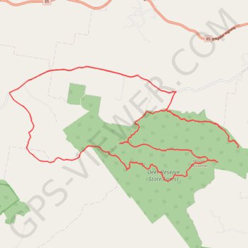
Name: Deer Reserve State Forest - Mount Mcconnel trail, distance, elevation, map, profile, GPS track
Start: Deer Reserve Road, Woolmar, Somerset Regional, Queensland, Australia (-26.96960 152.49848)
End: Deer Reserve Road, Woolmar, Somerset Regional, Queensland, Australia (-26.96958 152.49856)
Coordinates: -27.00528 152.42382 -26.95940 152.52666
Thank you for supporting this site ❤️
Make a donation
Make a donation
Gear up for your next adventure:
As an Amazon Associate, this site earns from qualifying purchases at no extra cost to you.