Make a donation
Gear up for your next adventure:
As an Amazon Associate, this site earns from qualifying purchases at no extra cost to you.
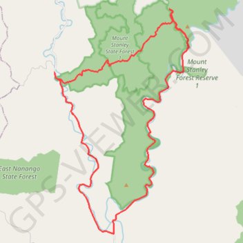
East Branch and West Branch Brisbane River
Interactive trail map
Make a donation
Gear up for your next adventure:
As an Amazon Associate, this site earns from qualifying purchases at no extra cost to you.
Trail profile
- Distance: 32.7 mi
- Elevation gain: 2,877 ft
- Maximum elevation: 1,775 ft
- Elevation loss: 2,881 ft
- Minimum elevation: 558 ft
Make a donation
Gear up for your next adventure:
As an Amazon Associate, this site earns from qualifying purchases at no extra cost to you.
About this trail
Name: East Branch and West Branch Brisbane River trail, distance, elevation, map, profile, GPS track
Start: Eastern Branch Road, Mount Stanley, Somerset Regional, Queensland, Australia (-26.67372 152.20146)
End: Eastern Branch Road, Mount Stanley, Somerset Regional, Queensland, Australia (-26.67344 152.20162)
Coordinates: -26.67501 152.16492 -26.55082 152.24774
Make a donation
Gear up for your next adventure:
As an Amazon Associate, this site earns from qualifying purchases at no extra cost to you.
Other hiking, mountain biking, running and outdoor activity trails
Click on a trail to view its statistics, map and profile.
Nanango - Brisbane River
Nanango State Forest. Mount Stanley State Forest. #MTB #Nanango #MountStanley
Distance: 32.4 mi • Elevation gain: 3,294 ft • Maximum elevation: 1,791 ft