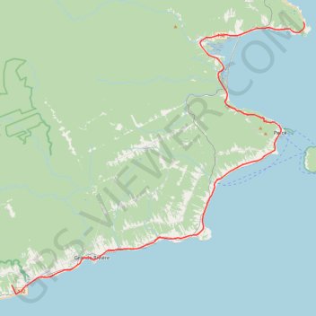
Saint-Georges-de-Malbaie - Saint-François-de-Pabos
Gulf of Saint Lawrence. #Bike #SaintLawrence #Atlantic
- Distance: 42.7 mi
- Elevation gain: 2,297 ft
- Maximum elevation: 466 ft
- Elevation loss: 2,303 ft
- Minimum elevation: -3 ft
Interactive trail map
Trail profile
- Distance: 42.7 mi
- Elevation gain: 2,297 ft
- Maximum elevation: 466 ft
- Elevation loss: 2,303 ft
- Minimum elevation: -3 ft
About this trail
Name: Saint-Georges-de-Malbaie - Saint-François-de-Pabos trail, distance, elevation, map, profile, GPS track
Coordinates: 48.36157 -64.61473 48.63159 -64.17735
Other hiking, mountain biking, running and outdoor activity trails
Click on a trail to view its statistics, map and profile.
Gaspé - Saint-Georges-de-Malbaie
Canada > Quebec > La Côte-de-Gaspé > Gaspé > Cap-aux-Os > D'Aiguillon
Forillon National Park. Gulf of Saint Lawrence. #Bike #Gaspé #SaintGeorgesDeMalbaie #Forillon #SaintLawrence #Atlantic
Distance: 47.1 mi • Elevation gain: 2,612 ft • Maximum elevation: 262 ft
Saint-François-de-Pabos - New Richmond
Canada > Quebec > Le Rocher-Percé > Chandler > Pabos
Gulf of Saint Lawrence. #Bike #SaintFrançoisDePabos #NewRichmond #SaintLawrence #Atlantic
Distance: 79.1 mi • Elevation gain: 3,048 ft • Maximum elevation: 318 ft