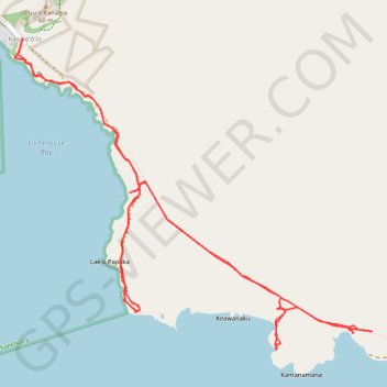
La Perouse Bay and King's Highway (Maui Island)
Hike along La Perouse Bay (Keoneʻōʻio Bay) and King's Highway from Keoneʻōʻio via Hoapali Trail, King's Highway and Hanamanioa Point Light on Maui Island. #Hiking #Sea #Pacific #Ocean #Volcano #Island #Hawaii #Nature #Mountain
- Distance: 6.7 mi
- Elevation gain: 453 ft
- Maximum elevation: 75 ft
- Elevation loss: 453 ft
- Minimum elevation: 0 ft
- Moving time: 2 h 53 m
- Moving speed: 2.3 mph
- Maximum speed: 3.4 mph
- Total time: 3 h 51 m
- Global speed: 1.7 mph
Interactive trail map
Trail profile
- Distance: 6.7 mi
- Elevation gain: 453 ft
- Maximum elevation: 75 ft
- Elevation loss: 453 ft
- Minimum elevation: 0 ft
- Moving time: 2 h 53 m
- Moving speed: 2.3 mph
- Maximum speed: 3.4 mph
- Total time: 3 h 51 m
- Global speed: 1.7 mph
About this trail
Name: La Perouse Bay and King's Highway (Maui Island) trail, distance, elevation, map, profile, GPS track
Start: Makena Alanui, Kanahena, Maui County, Hawaii, United States (20.60056 -156.41976)
End: Makena Alanui, Kanahena, Maui County, Hawaii, United States (20.60069 -156.41978)
Coordinates: 20.58089 -156.42032 20.60069 -156.39602
Topography: Maui County topographic map, elevation, terrain