Make a donation
Gear up for your next adventure:
As an Amazon Associate, this site earns from qualifying purchases at no extra cost to you.
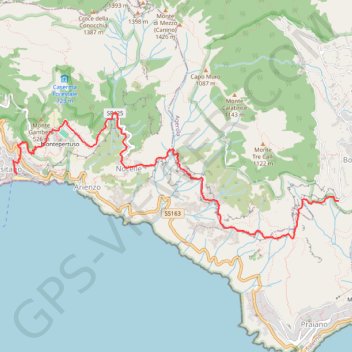
Path of the Gods | Sentiero degli Dei: Bomerano - Positano
- Distance: 5.2 mi
- Elevation gain: 2,021 ft
- Maximum elevation: 2,139 ft
- Elevation loss: 3,976 ft
- Minimum elevation: 39 ft
Interactive trail map
Make a donation
Gear up for your next adventure:
As an Amazon Associate, this site earns from qualifying purchases at no extra cost to you.
Trail profile
- Distance: 5.2 mi
- Elevation gain: 2,021 ft
- Maximum elevation: 2,139 ft
- Elevation loss: 3,976 ft
- Minimum elevation: 39 ft
Make a donation
Gear up for your next adventure:
As an Amazon Associate, this site earns from qualifying purchases at no extra cost to you.
About this trail
Name: Path of the Gods | Sentiero degli Dei: Bomerano - Positano trail, distance, elevation, map, profile, GPS track
Start: Via Sentiero degli Dei, Bomerano, Agerola, Naples, Campania, 80051, Italy (40.62502 14.53502)
Coordinates: 40.62078 14.48651 40.63493 14.53502
Make a donation
Gear up for your next adventure:
As an Amazon Associate, this site earns from qualifying purchases at no extra cost to you.
Other hiking, mountain biking, running and outdoor activity trails
Click on a trail to view its statistics, map and profile.
Path of the Gods | Sentiero degli Dei: Bomerano - Positano
Italy > Campania > Naples > Bomerano
https://en-hk.gps-viewer.com/track-lhff3/Path-of-the-Gods-Sentiero-degli-Dei-Bomerano-Positano/
Distance: 5.2 mi • Elevation gain: 2,034 ft • Maximum elevation: 2,139 ft
Positano - Santa Maria al Castello - Spiaggia di Fornillo
Italy > Campania > Salerno > Arienzo > Montepertuso
Distance: 5.1 mi • Elevation gain: 3,159 ft • Maximum elevation: 2,228 ft
Positano - Santa Maria al Castello - Spiaggia di Fornillo
Italy > Campania > Salerno > Arienzo > Montepertuso
Distance: 5.1 mi • Elevation gain: 3,159 ft • Maximum elevation: 2,228 ft