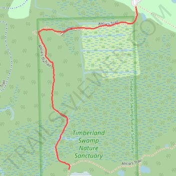
Trail in Timberland Nature Sanctuary in Springfield Township, MI
- Distance: 0.7 mi
- Elevation gain: 30 ft
- Maximum elevation: 1,030 ft
- Elevation loss: 23 ft
- Minimum elevation: 1,007 ft
- Moving time: 23 m 36 s
- Moving speed: 1.8 mph
- Maximum speed: 9.1 mph
- Total time: 30 m 20 s
- Global speed: 1.4 mph
Interactive trail map
Trail profile
- Distance: 0.7 mi
- Elevation gain: 30 ft
- Maximum elevation: 1,030 ft
- Elevation loss: 23 ft
- Minimum elevation: 1,007 ft
- Moving time: 23 m 36 s
- Moving speed: 1.8 mph
- Maximum speed: 9.1 mph
- Total time: 30 m 20 s
- Global speed: 1.4 mph
About this trail
Name: Trail in Timberland Nature Sanctuary in Springfield Township, MI trail, distance, elevation, map, profile, GPS track
Coordinates: 42.71712 -83.49635 42.72317 -83.49138
Topography: Oakland County topographic map, elevation, terrain