Thank you for supporting this site ❤️
Make a donation
Make a donation
Gear up for your next adventure:
As an Amazon Associate, this site earns from qualifying purchases at no extra cost to you.
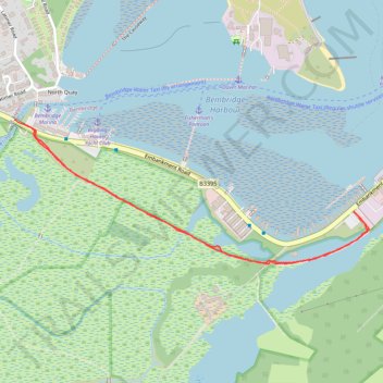
Bembridge old railway track
- Distance: 1.5 mi
- Elevation gain: 26 ft
- Maximum elevation: 7 ft
- Elevation loss: 23 ft
- Minimum elevation: -7 ft
- Moving time: 25 m 15 s
- Moving speed: 3.5 mph
- Maximum speed: 5.2 mph
- Total time: 26 m 2 s
- Global speed: 3.4 mph
Interactive trail map
Thank you for supporting this site ❤️
Make a donation
Make a donation
Gear up for your next adventure:
As an Amazon Associate, this site earns from qualifying purchases at no extra cost to you.
Trail profile
- Distance: 1.5 mi
- Elevation gain: 26 ft
- Maximum elevation: 7 ft
- Elevation loss: 23 ft
- Minimum elevation: -7 ft
- Moving time: 25 m 15 s
- Moving speed: 3.5 mph
- Maximum speed: 5.2 mph
- Total time: 26 m 2 s
- Global speed: 3.4 mph
Thank you for supporting this site ❤️
Make a donation
Make a donation
Gear up for your next adventure:
As an Amazon Associate, this site earns from qualifying purchases at no extra cost to you.
About this trail
Name: Bembridge old railway track trail, distance, elevation, map, profile, GPS track
Start: Embankment Road, Bembridge, Isle of Wight, England, PO33 1XG, United Kingdom (50.69329 -1.10875)
End: Embankment Road, St. Helens, Isle of Wight, England, PO33 1YS, United Kingdom (50.69343 -1.10924)
Coordinates: 50.68983 -1.10924 50.69343 -1.09526
Thank you for supporting this site ❤️
Make a donation
Make a donation
Gear up for your next adventure:
As an Amazon Associate, this site earns from qualifying purchases at no extra cost to you.