Thank you for supporting this site ❤️
Make a donation
Make a donation
Gear up for your next adventure:
As an Amazon Associate, this site earns from qualifying purchases at no extra cost to you.
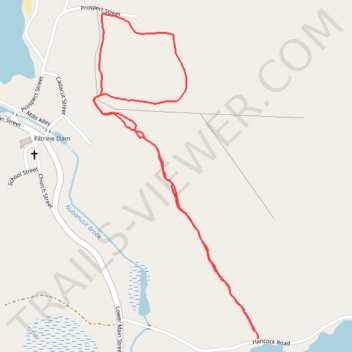
Zophar Willard Trail
- Distance: 1.6 mi
- Elevation gain: 210 ft
- Maximum elevation: 1,411 ft
- Elevation loss: 217 ft
- Minimum elevation: 1,204 ft
- Moving time: 39 m 36 s
- Moving speed: 2.4 mph
- Maximum speed: 4.1 mph
- Total time: 43 m 36 s
- Global speed: 2.2 mph
Interactive trail map
Thank you for supporting this site ❤️
Make a donation
Make a donation
Gear up for your next adventure:
As an Amazon Associate, this site earns from qualifying purchases at no extra cost to you.
Trail profile
- Distance: 1.6 mi
- Elevation gain: 210 ft
- Maximum elevation: 1,411 ft
- Elevation loss: 217 ft
- Minimum elevation: 1,204 ft
- Moving time: 39 m 36 s
- Moving speed: 2.4 mph
- Maximum speed: 4.1 mph
- Total time: 43 m 36 s
- Global speed: 2.2 mph
Thank you for supporting this site ❤️
Make a donation
Make a donation
Gear up for your next adventure:
As an Amazon Associate, this site earns from qualifying purchases at no extra cost to you.
About this trail
Name: Zophar Willard Trail trail, distance, elevation, map, profile, GPS track
Coordinates: 42.93998 -72.09208 42.94804 -72.08652
Topography: Cheshire County topographic map, elevation, terrain
Thank you for supporting this site ❤️
Make a donation
Make a donation
Gear up for your next adventure:
As an Amazon Associate, this site earns from qualifying purchases at no extra cost to you.