Thank you for supporting this site ❤️
Make a donation
Make a donation
Gear up for your next adventure:
As an Amazon Associate, this site earns from qualifying purchases at no extra cost to you.
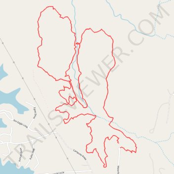
Creekside Loop and Leatherwood Loop trails
- Distance: 4.2 mi
- Elevation gain: 430 ft
- Maximum elevation: 801 ft
- Elevation loss: 440 ft
- Minimum elevation: 676 ft
- Moving time: 2 h 5 m
- Moving speed: 2.0 mph
- Maximum speed: 7.2 mph
- Total time: 2 h 35 m
- Global speed: 1.6 mph
Interactive trail map
Thank you for supporting this site ❤️
Make a donation
Make a donation
Gear up for your next adventure:
As an Amazon Associate, this site earns from qualifying purchases at no extra cost to you.
Trail profile
- Distance: 4.2 mi
- Elevation gain: 430 ft
- Maximum elevation: 801 ft
- Elevation loss: 440 ft
- Minimum elevation: 676 ft
- Moving time: 2 h 5 m
- Moving speed: 2.0 mph
- Maximum speed: 7.2 mph
- Total time: 2 h 35 m
- Global speed: 1.6 mph
Thank you for supporting this site ❤️
Make a donation
Make a donation
Gear up for your next adventure:
As an Amazon Associate, this site earns from qualifying purchases at no extra cost to you.
About this trail
Name: Creekside Loop and Leatherwood Loop trails trail, distance, elevation, map, profile, GPS track
Start: Waterfield Lane, Rockingham County, North Carolina, United States (36.31147 -80.00408)
Coordinates: 36.31014 -80.01105 36.32102 -80.00270
Topography: Rockingham County topographic map, elevation, terrain
Thank you for supporting this site ❤️
Make a donation
Make a donation
Gear up for your next adventure:
As an Amazon Associate, this site earns from qualifying purchases at no extra cost to you.