Thank you for supporting this site ❤️
Make a donation
Make a donation
Gear up for your next adventure:
As an Amazon Associate, this site earns from qualifying purchases at no extra cost to you.
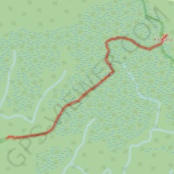
Kilohana Lookout
- Distance: 1.6 mi
- Elevation gain: 141 ft
- Maximum elevation: 4,049 ft
- Elevation loss: 95 ft
- Minimum elevation: 3,921 ft
- Moving time: 48 m 19 s
- Moving speed: 1.9 mph
- Maximum speed: 4.1 mph
- Total time: 56 m 55 s
- Global speed: 1.7 mph
Interactive trail map
Thank you for supporting this site ❤️
Make a donation
Make a donation
Gear up for your next adventure:
As an Amazon Associate, this site earns from qualifying purchases at no extra cost to you.
Trail profile
- Distance: 1.6 mi
- Elevation gain: 141 ft
- Maximum elevation: 4,049 ft
- Elevation loss: 95 ft
- Minimum elevation: 3,921 ft
- Moving time: 48 m 19 s
- Moving speed: 1.9 mph
- Maximum speed: 4.1 mph
- Total time: 56 m 55 s
- Global speed: 1.7 mph
Thank you for supporting this site ❤️
Make a donation
Make a donation
Gear up for your next adventure:
As an Amazon Associate, this site earns from qualifying purchases at no extra cost to you.
About this trail
Name: Kilohana Lookout trail, distance, elevation, map, profile, GPS track
Start: Alaka'i Swamp Trail, Kauaʻi County, Hawaii, United States (22.14720 -159.60899)
End: Alaka'i Swamp Trail, Kauaʻi County, Hawaii, United States (22.15632 -159.59375)
Coordinates: 22.14720 -159.60899 22.15632 -159.59375
Topography: Kauaʻi County topographic map, elevation, terrain
Thank you for supporting this site ❤️
Make a donation
Make a donation
Gear up for your next adventure:
As an Amazon Associate, this site earns from qualifying purchases at no extra cost to you.