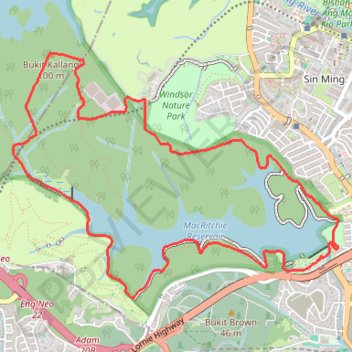
MacRitchie Reservoir and TreeTop Walk Loop
- Distance: 7.6 mi
- Elevation gain: 679 ft
- Maximum elevation: 292 ft
- Elevation loss: 679 ft
- Minimum elevation: 33 ft
Interactive trail map
Trail profile
- Distance: 7.6 mi
- Elevation gain: 679 ft
- Maximum elevation: 292 ft
- Elevation loss: 679 ft
- Minimum elevation: 33 ft
About this trail
Name: MacRitchie Reservoir and TreeTop Walk Loop trail, distance, elevation, map, profile, GPS track
Coordinates: 1.33834 103.80595 1.36141 103.83653
Other hiking, mountain biking, running and outdoor activity trails
Click on a trail to view its statistics, map and profile.
Bukit Timah Hill - MacRitchie Reservoir
Distance: 9.2 mi • Elevation gain: 951 ft • Maximum elevation: 548 ft
新加坡-麦里芝自然小径
Distance: 7.4 mi • Elevation gain: 630 ft • Maximum elevation: 292 ft
The Green Corridor - Singapore
Distance: 13.8 mi • Elevation gain: 548 ft • Maximum elevation: 144 ft
Tree Top Walk & Bukit Timah Hill in Central Catchment Nature Reserve
Distance: 8.8 mi • Elevation gain: 1,047 ft • Maximum elevation: 545 ft
Directions from Duck Tour Ramp to Marina Boulevard, Singapore
Distance: 65.5 mi • Elevation gain: 2,664 ft • Maximum elevation: 167 ft