Thank you for supporting this site ❤️
Make a donation
Make a donation
Gear up for your next adventure:
As an Amazon Associate, this site earns from qualifying purchases at no extra cost to you.
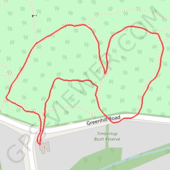
Woowookarung Park with puppies to look at new tracks
Morning Walk
- Distance: 0.8 mi
- Elevation gain: 59 ft
- Maximum elevation: 1,722 ft
- Elevation loss: 59 ft
- Minimum elevation: 1,667 ft
- Moving time: 16 m 36 s
- Moving speed: 2.8 mph
- Maximum speed: 4.4 mph
- Total time: 16 m 36 s
- Global speed: 2.8 mph
Interactive trail map
Thank you for supporting this site ❤️
Make a donation
Make a donation
Gear up for your next adventure:
As an Amazon Associate, this site earns from qualifying purchases at no extra cost to you.
Trail profile
- Distance: 0.8 mi
- Elevation gain: 59 ft
- Maximum elevation: 1,722 ft
- Elevation loss: 59 ft
- Minimum elevation: 1,667 ft
- Moving time: 16 m 36 s
- Moving speed: 2.8 mph
- Maximum speed: 4.4 mph
- Total time: 16 m 36 s
- Global speed: 2.8 mph
Thank you for supporting this site ❤️
Make a donation
Make a donation
Gear up for your next adventure:
As an Amazon Associate, this site earns from qualifying purchases at no extra cost to you.
About this trail
Name: Woowookarung Park with puppies to look at new tracks trail, distance, elevation, map, profile, GPS track
Coordinates: -37.61770 143.88877 -37.61544 143.89250
Thank you for supporting this site ❤️
Make a donation
Make a donation
Gear up for your next adventure:
As an Amazon Associate, this site earns from qualifying purchases at no extra cost to you.
Other hiking, mountain biking, running and outdoor activity trails
Click on a trail to view its statistics, map and profile.
Mount Helen Afternoon Walk
Australia > Victoria > Ballarat
Mapping tracks while walking dogs
Distance: 1.7 mi • Elevation gain: 161 ft • Maximum elevation: 1,778 ft