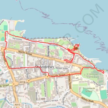
St Andrews
- Distance: 2.6 mi
- Elevation gain: 233 ft
- Maximum elevation: 85 ft
- Elevation loss: 233 ft
- Minimum elevation: 0 ft
- Moving time: 1 h 12 m
- Moving speed: 2.1 mph
- Maximum speed: 7.0 mph
- Total time: 2 h 44 m
- Global speed: 0.9 mph
Interactive trail map
Trail profile
- Distance: 2.6 mi
- Elevation gain: 233 ft
- Maximum elevation: 85 ft
- Elevation loss: 233 ft
- Minimum elevation: 0 ft
- Moving time: 1 h 12 m
- Moving speed: 2.1 mph
- Maximum speed: 7.0 mph
- Total time: 2 h 44 m
- Global speed: 0.9 mph
About this trail
Name: St Andrews trail, distance, elevation, map, profile, GPS track
Start: 46, North Street, St Andrews, Fife, Scotland, KY16 9AQ, United Kingdom (56.34099 -2.79202)
End: 52, North Street, St Andrews, Fife, Scotland, KY16 9AQ, United Kingdom (56.34100 -2.79219)
Coordinates: 56.33937 -2.80281 56.34387 -2.78502