Make a donation
Gear up for your next adventure:
As an Amazon Associate, this site earns from qualifying purchases at no extra cost to you.
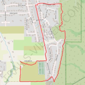
Bonneville Shoreline Trail and Centenial Trail loop
- Distance: 3.1 mi
- Elevation gain: 568 ft
- Maximum elevation: 5,348 ft
- Elevation loss: 558 ft
- Minimum elevation: 4,849 ft
- Moving time: 1 h 12 m
- Moving speed: 2.6 mph
- Maximum speed: 9.7 mph
- Total time: 1 h 14 m
- Global speed: 2.5 mph
Interactive trail map
Make a donation
Gear up for your next adventure:
As an Amazon Associate, this site earns from qualifying purchases at no extra cost to you.
Trail profile
- Distance: 3.1 mi
- Elevation gain: 568 ft
- Maximum elevation: 5,348 ft
- Elevation loss: 558 ft
- Minimum elevation: 4,849 ft
- Moving time: 1 h 12 m
- Moving speed: 2.6 mph
- Maximum speed: 9.7 mph
- Total time: 1 h 14 m
- Global speed: 2.5 mph
Make a donation
Gear up for your next adventure:
As an Amazon Associate, this site earns from qualifying purchases at no extra cost to you.
About this trail
Name: Bonneville Shoreline Trail and Centenial Trail loop trail, distance, elevation, map, profile, GPS track
Start: 2500 North, North Logan, Cache County, Utah, 84341, United States (41.77575 -111.78598)
End: 2500 North, North Logan, Cache County, Utah, 84341, United States (41.77667 -111.78596)
Coordinates: 41.77306 -111.78612 41.78669 -111.77555
Topography: Cache County topographic map, elevation, terrain
Make a donation
Gear up for your next adventure:
As an Amazon Associate, this site earns from qualifying purchases at no extra cost to you.
Other hiking, mountain biking, running and outdoor activity trails
Click on a trail to view its statistics, map and profile.
Uinta-Wasatch-Cache National Forest
United States > Utah > Cache County
Distance: 5.5 mi • Elevation gain: 207 ft • Maximum elevation: 5,722 ft