Make a donation
Gear up for your next adventure:
As an Amazon Associate, this site earns from qualifying purchases at no extra cost to you.
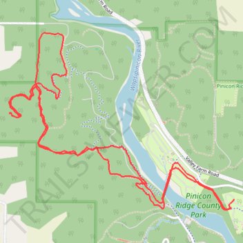
Pinicon Ridge County Park trails
- Distance: 4.5 mi
- Elevation gain: 512 ft
- Maximum elevation: 1,001 ft
- Elevation loss: 515 ft
- Minimum elevation: 833 ft
- Moving time: 55 m 28 s
- Moving speed: 4.9 mph
- Maximum speed: 8.4 mph
- Total time: 55 m 28 s
- Global speed: 4.9 mph
Interactive trail map
Make a donation
Gear up for your next adventure:
As an Amazon Associate, this site earns from qualifying purchases at no extra cost to you.
Trail profile
- Distance: 4.5 mi
- Elevation gain: 512 ft
- Maximum elevation: 1,001 ft
- Elevation loss: 515 ft
- Minimum elevation: 833 ft
- Moving time: 55 m 28 s
- Moving speed: 4.9 mph
- Maximum speed: 8.4 mph
- Total time: 55 m 28 s
- Global speed: 4.9 mph
Make a donation
Gear up for your next adventure:
As an Amazon Associate, this site earns from qualifying purchases at no extra cost to you.
About this trail
Name: Pinicon Ridge County Park trails trail, distance, elevation, map, profile, GPS track
Coordinates: 42.21612 -91.55605 42.22684 -91.53767
Topography: Linn County topographic map, elevation, terrain
Make a donation
Gear up for your next adventure:
As an Amazon Associate, this site earns from qualifying purchases at no extra cost to you.
Other hiking, mountain biking, running and outdoor activity trails
Click on a trail to view its statistics, map and profile.
Deep Woods - Mountain Bike Ride in Pinicon Ridge County Park
United States > Iowa > Linn County
Distance: 2.0 mi • Elevation gain: 213 ft • Maximum elevation: 955 ft
Riverline and Echo Bench ride
United States > Iowa > Linn County
Distance: 5.8 mi • Elevation gain: 614 ft • Maximum elevation: 974 ft
Pinicon Ridge County Park
United States > Iowa > Linn County
Distance: 6.0 mi • Elevation gain: 633 ft • Maximum elevation: 981 ft