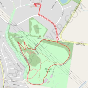
Bayview Park Loop Walk
- Distance: 2.7 mi
- Elevation gain: 427 ft
- Maximum elevation: 538 ft
- Elevation loss: 423 ft
- Minimum elevation: 322 ft
- Moving time: 59 m 43 s
- Moving speed: 2.7 mph
- Maximum speed: 4.1 mph
- Total time: 1 h 23 s
- Global speed: 2.7 mph
Interactive trail map
Trail profile
- Distance: 2.7 mi
- Elevation gain: 427 ft
- Maximum elevation: 538 ft
- Elevation loss: 423 ft
- Minimum elevation: 322 ft
- Moving time: 59 m 43 s
- Moving speed: 2.7 mph
- Maximum speed: 4.1 mph
- Total time: 1 h 23 s
- Global speed: 2.7 mph
About this trail
Name: Bayview Park Loop Walk trail, distance, elevation, map, profile, GPS track
Coordinates: -38.00474 145.32500 -37.99444 145.33335