Make a donation
Gear up for your next adventure:
As an Amazon Associate, this site earns from qualifying purchases at no extra cost to you.
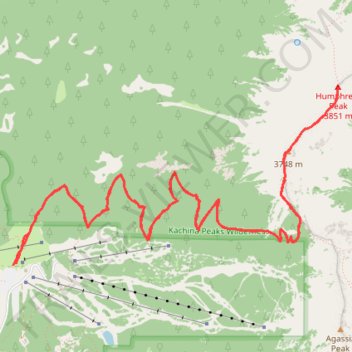
Humphreys Peak Trail in Kachina Peaks Wilderness
Humphreys Peak Trail, located in the Kachina Peaks Wilderness in Arizona, is a scenic and challenging hike that leads to the state's highest point. As the trail ascends, it traverses alpine meadows, lush forests and ancient volcanic fields, leading to a saddle that reveals panoramic views of the Inner Basin and neighboring peaks. Upon reaching the summit, hikers are rewarded with expansive vistas stretching across the Arizona landscape, including distant deserts, other mountain ranges, and glimpses of the Grand Canyon on clear days. #Hiking #Mountain #Forest #Overlook #Nature
- Distance: 10.1 mi
- Elevation gain: 3,356 ft
- Maximum elevation: 12,579 ft
- Elevation loss: 3,337 ft
- Minimum elevation: 9,291 ft
- Moving time: 5 h 3 m
- Moving speed: 2.0 mph
- Maximum speed: 5.3 mph
- Total time: 8 h 8 m
- Global speed: 1.2 mph
Interactive trail map
Make a donation
Gear up for your next adventure:
As an Amazon Associate, this site earns from qualifying purchases at no extra cost to you.
Trail profile
- Distance: 10.1 mi
- Elevation gain: 3,356 ft
- Maximum elevation: 12,579 ft
- Elevation loss: 3,337 ft
- Minimum elevation: 9,291 ft
- Moving time: 5 h 3 m
- Moving speed: 2.0 mph
- Maximum speed: 5.3 mph
- Total time: 8 h 8 m
- Global speed: 1.2 mph
Make a donation
Gear up for your next adventure:
As an Amazon Associate, this site earns from qualifying purchases at no extra cost to you.
About this trail
Name: Humphreys Peak Trail in Kachina Peaks Wilderness trail, distance, elevation, map, profile, GPS track
Start: Humphreys Peak Trail, Coconino County, Arizona, United States (35.33134 -111.71157)
End: Humphreys Peak Trail, Coconino County, Arizona, United States (35.33143 -111.71120)
Coordinates: 35.33134 -111.71157 35.34641 -111.67793
Topography: Coconino County topographic map, elevation, terrain
Make a donation
Gear up for your next adventure:
As an Amazon Associate, this site earns from qualifying purchases at no extra cost to you.
Other hiking, mountain biking, running and outdoor activity trails
Click on a trail to view its statistics, map and profile.