Thank you for supporting this site ❤️
Make a donation
Make a donation
Gear up for your next adventure:
As an Amazon Associate, this site earns from qualifying purchases at no extra cost to you.
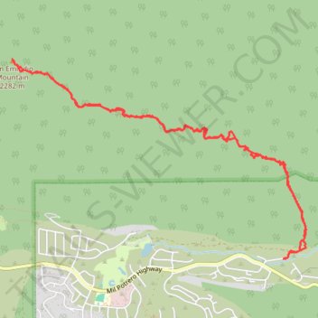
San Emigdio Mountain Eastern Approach
- Distance: 7.1 mi
- Elevation gain: 2,700 ft
- Maximum elevation: 7,467 ft
- Elevation loss: 2,697 ft
- Minimum elevation: 4,905 ft
- Moving time: 4 h 19 m
- Moving speed: 1.6 mph
- Maximum speed: 3.6 mph
- Total time: 7 h 25 m
- Global speed: 1.0 mph
Interactive trail map
Thank you for supporting this site ❤️
Make a donation
Make a donation
Gear up for your next adventure:
As an Amazon Associate, this site earns from qualifying purchases at no extra cost to you.
Trail profile
- Distance: 7.1 mi
- Elevation gain: 2,700 ft
- Maximum elevation: 7,467 ft
- Elevation loss: 2,697 ft
- Minimum elevation: 4,905 ft
- Moving time: 4 h 19 m
- Moving speed: 1.6 mph
- Maximum speed: 3.6 mph
- Total time: 7 h 25 m
- Global speed: 1.0 mph
Thank you for supporting this site ❤️
Make a donation
Make a donation
Gear up for your next adventure:
As an Amazon Associate, this site earns from qualifying purchases at no extra cost to you.
About this trail
Name: San Emigdio Mountain Eastern Approach trail, distance, elevation, map, profile, GPS track
Coordinates: 34.85388 -119.17899 34.87340 -119.14391
Topography: Kern County topographic map, elevation, terrain
Thank you for supporting this site ❤️
Make a donation
Make a donation
Gear up for your next adventure:
As an Amazon Associate, this site earns from qualifying purchases at no extra cost to you.