Thank you for supporting this site ❤️
Make a donation
Make a donation
Gear up for your next adventure:
As an Amazon Associate, this site earns from qualifying purchases at no extra cost to you.
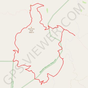
Manzano Peak Loop via Cottonwood Trail, Pine Shadow Trail and Kayser Mill Trail
- Distance: 11.8 mi
- Elevation gain: 3,205 ft
- Maximum elevation: 9,915 ft
- Elevation loss: 3,205 ft
- Minimum elevation: 7,215 ft
- Moving time: 5 h 31 m
- Moving speed: 2.1 mph
- Maximum speed: 3.8 mph
- Total time: 6 h 37 m
- Global speed: 1.8 mph
Interactive trail map
Thank you for supporting this site ❤️
Make a donation
Make a donation
Gear up for your next adventure:
As an Amazon Associate, this site earns from qualifying purchases at no extra cost to you.
Trail profile
- Distance: 11.8 mi
- Elevation gain: 3,205 ft
- Maximum elevation: 9,915 ft
- Elevation loss: 3,205 ft
- Minimum elevation: 7,215 ft
- Moving time: 5 h 31 m
- Moving speed: 2.1 mph
- Maximum speed: 3.8 mph
- Total time: 6 h 37 m
- Global speed: 1.8 mph
Thank you for supporting this site ❤️
Make a donation
Make a donation
Gear up for your next adventure:
As an Amazon Associate, this site earns from qualifying purchases at no extra cost to you.
About this trail
Name: Manzano Peak Loop via Cottonwood Trail, Pine Shadow Trail and Kayser Mill Trail trail, distance, elevation, map, profile, GPS track
Start: Forest 422 Road, Torrance County, New Mexico, United States (34.58701 -106.42116)
Coordinates: 34.56324 -106.45771 34.60272 -106.42116
Topography: Torrance County topographic map, elevation, terrain
Thank you for supporting this site ❤️
Make a donation
Make a donation
Gear up for your next adventure:
As an Amazon Associate, this site earns from qualifying purchases at no extra cost to you.