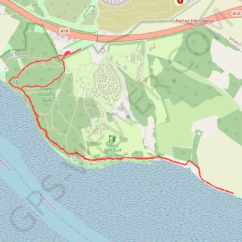
England Coast Path Eastwards from Bridge Wood
- Distance: 3.4 mi
- Elevation gain: 240 ft
- Maximum elevation: 118 ft
- Elevation loss: 243 ft
- Minimum elevation: 0 ft
- Moving time: 1 h 27 m
- Moving speed: 2.3 mph
- Maximum speed: 11.9 mph
- Total time: 1 h 31 m
- Global speed: 2.2 mph
Interactive trail map
Trail profile
- Distance: 3.4 mi
- Elevation gain: 240 ft
- Maximum elevation: 118 ft
- Elevation loss: 243 ft
- Minimum elevation: 0 ft
- Moving time: 1 h 27 m
- Moving speed: 2.3 mph
- Maximum speed: 11.9 mph
- Total time: 1 h 31 m
- Global speed: 2.2 mph
About this trail
Name: England Coast Path Eastwards from Bridge Wood trail, distance, elevation, map, profile, GPS track
Start: A14, Ravenswood, Ipswich, Suffolk, England, IP10 0JR, United Kingdom (52.02257 1.18750)
Coordinates: 52.01320 1.18113 52.02272 1.20505
Other hiking, mountain biking, running and outdoor activity trails
Click on a trail to view its statistics, map and profile.
England Coast Path Westwards from Nacton Shore
United Kingdom > England > Suffolk > Ipswich > Nacton
Distance: 3.1 mi • Elevation gain: 161 ft • Maximum elevation: 59 ft
Orwell Bridge to Bridge Wood Coast Path
United Kingdom > England > Suffolk > East Suffolk > Nacton
Distance: 2.0 mi • Elevation gain: 184 ft • Maximum elevation: 118 ft