Thank you for supporting this site ❤️
Make a donation
Make a donation
Gear up for your next adventure:
As an Amazon Associate, this site earns from qualifying purchases at no extra cost to you.
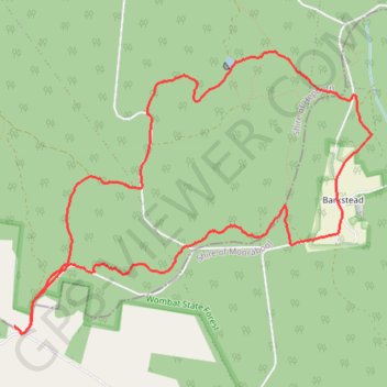
Mollonghip-Barkstead, Wombat State Forest, Circuit
- Distance: 6.9 mi
- Elevation gain: 558 ft
- Maximum elevation: 2,329 ft
- Elevation loss: 558 ft
- Minimum elevation: 2,054 ft
- Moving time: 2 h 27 m
- Moving speed: 2.8 mph
- Maximum speed: 4.6 mph
- Total time: 3 h 2 m
- Global speed: 2.3 mph
Interactive trail map
Thank you for supporting this site ❤️
Make a donation
Make a donation
Gear up for your next adventure:
As an Amazon Associate, this site earns from qualifying purchases at no extra cost to you.
Trail profile
- Distance: 6.9 mi
- Elevation gain: 558 ft
- Maximum elevation: 2,329 ft
- Elevation loss: 558 ft
- Minimum elevation: 2,054 ft
- Moving time: 2 h 27 m
- Moving speed: 2.8 mph
- Maximum speed: 4.6 mph
- Total time: 3 h 2 m
- Global speed: 2.3 mph
Thank you for supporting this site ❤️
Make a donation
Make a donation
Gear up for your next adventure:
As an Amazon Associate, this site earns from qualifying purchases at no extra cost to you.
About this trail
Name: Mollonghip-Barkstead, Wombat State Forest, Circuit trail, distance, elevation, map, profile, GPS track
Start: Goldfields Track, Mollongghip, Shire of Hepburn, Victoria, Australia (-37.46958 144.05439)
End: Goldfields Track, Mollongghip, Shire of Hepburn, Victoria, Australia (-37.46955 144.05433)
Coordinates: -37.47014 144.05433 -37.44804 144.08962
Thank you for supporting this site ❤️
Make a donation
Make a donation
Gear up for your next adventure:
As an Amazon Associate, this site earns from qualifying purchases at no extra cost to you.