Make a donation
Gear up for your next adventure:
As an Amazon Associate, this site earns from qualifying purchases at no extra cost to you.
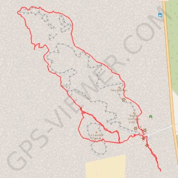
Roques de Garcia - El Teide
- Distance: 3.4 mi
- Elevation gain: 833 ft
- Maximum elevation: 7,136 ft
- Elevation loss: 827 ft
- Minimum elevation: 6,614 ft
Interactive trail map
Make a donation
Gear up for your next adventure:
As an Amazon Associate, this site earns from qualifying purchases at no extra cost to you.
Trail profile
- Distance: 3.4 mi
- Elevation gain: 833 ft
- Maximum elevation: 7,136 ft
- Elevation loss: 827 ft
- Minimum elevation: 6,614 ft
Make a donation
Gear up for your next adventure:
As an Amazon Associate, this site earns from qualifying purchases at no extra cost to you.
About this trail
Name: Roques de Garcia - El Teide trail, distance, elevation, map, profile, GPS track
Start: Mirador de la Ruleta, La Orotava, Santa Cruz de Tenerife, Canary Islands, Spain (28.22321 -16.63100)
Coordinates: 28.22068 -16.64089 28.23204 -16.62967
Make a donation
Gear up for your next adventure:
As an Amazon Associate, this site earns from qualifying purchases at no extra cost to you.
Other hiking, mountain biking, running and outdoor activity trails
Click on a trail to view its statistics, map and profile.
LONG TRAIL GR - 131 TENERIFE (CANARY ISLANDS) GR131 GR 131|trackspotting.com
Spain > El Rosario > La Esperanza
Distance: 54.5 mi • Elevation gain: 14,557 ft • Maximum elevation: 7,887 ft