Thank you for supporting this site ❤️
Make a donation
Make a donation
Gear up for your next adventure:
As an Amazon Associate, this site earns from qualifying purchases at no extra cost to you.
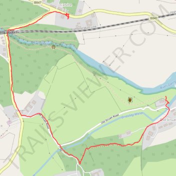
Walk at Calvin and Old Struan
- Distance: 1.2 mi
- Elevation gain: 161 ft
- Maximum elevation: 630 ft
- Elevation loss: 66 ft
- Minimum elevation: 528 ft
- Moving time: 27 m 32 s
- Moving speed: 2.5 mph
- Maximum speed: 6.5 mph
- Total time: 36 m 29 s
- Global speed: 1.9 mph
Interactive trail map
Thank you for supporting this site ❤️
Make a donation
Make a donation
Gear up for your next adventure:
As an Amazon Associate, this site earns from qualifying purchases at no extra cost to you.
Trail profile
- Distance: 1.2 mi
- Elevation gain: 161 ft
- Maximum elevation: 630 ft
- Elevation loss: 66 ft
- Minimum elevation: 528 ft
- Moving time: 27 m 32 s
- Moving speed: 2.5 mph
- Maximum speed: 6.5 mph
- Total time: 36 m 29 s
- Global speed: 1.9 mph
Thank you for supporting this site ❤️
Make a donation
Make a donation
Gear up for your next adventure:
As an Amazon Associate, this site earns from qualifying purchases at no extra cost to you.
About this trail
Name: Walk at Calvin and Old Struan trail, distance, elevation, map, profile, GPS track
End: B847, Calvine, Perth and Kinross, Scotland, PH18 5UA, United Kingdom (56.76799 -3.95715)
Coordinates: 56.76185 -3.96181 56.76820 -3.94947
Thank you for supporting this site ❤️
Make a donation
Make a donation
Gear up for your next adventure:
As an Amazon Associate, this site earns from qualifying purchases at no extra cost to you.