Make a donation
Gear up for your next adventure:
As an Amazon Associate, this site earns from qualifying purchases at no extra cost to you.
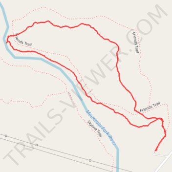
Friends Loop Trail in Beavers Bend State Park
The Friends Trail Loop in Beavers Bend State Park offers hikers a diverse experience, beginning with a steep ascent through dense forests, leading to panoramic views of the Mountain Fork River. As the trail descends, it meanders along the riverbank, providing opportunities to observe unique rock formations and enjoy the tranquil sounds of flowing water. The path is well-maintained, though some sections can be challenging due to the elevation changes. #Hiking #Loop #Forest #Nature #River
- Distance: 1.5 mi
- Elevation gain: 226 ft
- Maximum elevation: 696 ft
- Elevation loss: 226 ft
- Minimum elevation: 495 ft
- Moving time: 56 m 43 s
- Moving speed: 1.6 mph
- Maximum speed: 6.0 mph
- Total time: 1 h 15 m
- Global speed: 1.2 mph
Interactive trail map
Make a donation
Gear up for your next adventure:
As an Amazon Associate, this site earns from qualifying purchases at no extra cost to you.
Trail profile
- Distance: 1.5 mi
- Elevation gain: 226 ft
- Maximum elevation: 696 ft
- Elevation loss: 226 ft
- Minimum elevation: 495 ft
- Moving time: 56 m 43 s
- Moving speed: 1.6 mph
- Maximum speed: 6.0 mph
- Total time: 1 h 15 m
- Global speed: 1.2 mph
Make a donation
Gear up for your next adventure:
As an Amazon Associate, this site earns from qualifying purchases at no extra cost to you.
About this trail
Name: Friends Loop Trail in Beavers Bend State Park trail, distance, elevation, map, profile, GPS track
Start: Friends Trail, Stephens Gap, McCurtain County, Oklahoma, United States (34.14530 -94.69001)
End: Friends Trail, Stephens Gap, McCurtain County, Oklahoma, United States (34.14528 -94.69003)
Coordinates: 34.14528 -94.69765 34.15079 -94.68949
Topography: McCurtain County topographic map, elevation, terrain
Make a donation
Gear up for your next adventure:
As an Amazon Associate, this site earns from qualifying purchases at no extra cost to you.
Other hiking, mountain biking, running and outdoor activity trails
Click on a trail to view its statistics, map and profile.
Skyline Trail Loop in Beavers Bend State Park
United States > Oklahoma > McCurtain County
The Skyline Trail is a challenging loop hike that rewards adventurous visitors with sweeping views of the surrounding Ouachita Mountains, lush forests, glimpses of the Mountain Fork River below and even a hidden waterfall nestled in the forest. The trail leads hikers through rocky paths, forested ridges, and…
Distance: 8.5 mi • Elevation gain: 1,476 ft • Maximum elevation: 863 ft
Beaver Lodge Nature Trail along Mountain Fork River in Beavers Bend State Park
United States > Oklahoma > McCurtain County > Stephens Gap
The Beaver Lodge Nature Trail offers a delightful escape into nature, winding along the beautiful Mountain Fork River. Hikers will appreciate the tranquil sounds of rushing water and the vibrant scenery, including a stunning waterfall that serves as a focal point of the route. This accessible trail, known for…
Distance: 3.0 mi • Elevation gain: 318 ft • Maximum elevation: 614 ft
Friends Loop Trail in Beavers Bend State Park
United States > Oklahoma > McCurtain County > Stephens Gap
The Friends Trail is a moderately challenging loop hike that showcases the region’s natural beauty with captivating views of the Mountain Fork River and Broken Bow Lake. As hikers traverse the rugged path, they’re met with steep forested inclines and rocky stretches that offer glimpses of cascading…
Distance: 1.6 mi • Elevation gain: 269 ft • Maximum elevation: 699 ft