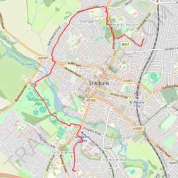
St Albans Green Ring
- Distance: 4.0 mi
- Elevation gain: 226 ft
- Maximum elevation: 420 ft
- Elevation loss: 167 ft
- Minimum elevation: 259 ft
- Moving time: 35 m 18 s
- Moving speed: 6.8 mph
- Maximum speed: 20.0 mph
- Total time: 36 m 12 s
- Global speed: 6.6 mph
Interactive trail map
Trail profile
- Distance: 4.0 mi
- Elevation gain: 226 ft
- Maximum elevation: 420 ft
- Elevation loss: 167 ft
- Minimum elevation: 259 ft
- Moving time: 35 m 18 s
- Moving speed: 6.8 mph
- Maximum speed: 20.0 mph
- Total time: 36 m 12 s
- Global speed: 6.6 mph
About this trail
Name: St Albans Green Ring trail, distance, elevation, map, profile, GPS track
Coordinates: 51.73808 -0.35568 51.76596 -0.32560
Other hiking, mountain biking, running and outdoor activity trails
Click on a trail to view its statistics, map and profile.
Colne Valley walk, St Albans
United Kingdom > England > Hertfordshire > St Albans
Distance: 1.8 mi • Elevation gain: 52 ft • Maximum elevation: 341 ft