Make a donation
Gear up for your next adventure:
As an Amazon Associate, this site earns from qualifying purchases at no extra cost to you.
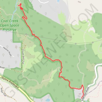
Alpine Trail, in and near Coal Creek Open Space Preserve, San Mateo Cty, CA
- Distance: 1.6 mi
- Elevation gain: 36 ft
- Maximum elevation: 2,162 ft
- Elevation loss: 597 ft
- Minimum elevation: 1,591 ft
- Moving time: 41 m 22 s
- Moving speed: 2.4 mph
- Maximum speed: 4.3 mph
- Total time: 44 m 59 s
- Global speed: 2.2 mph
Interactive trail map
Make a donation
Gear up for your next adventure:
As an Amazon Associate, this site earns from qualifying purchases at no extra cost to you.
Trail profile
- Distance: 1.6 mi
- Elevation gain: 36 ft
- Maximum elevation: 2,162 ft
- Elevation loss: 597 ft
- Minimum elevation: 1,591 ft
- Moving time: 41 m 22 s
- Moving speed: 2.4 mph
- Maximum speed: 4.3 mph
- Total time: 44 m 59 s
- Global speed: 2.2 mph
Make a donation
Gear up for your next adventure:
As an Amazon Associate, this site earns from qualifying purchases at no extra cost to you.
About this trail
Name: Alpine Trail, in and near Coal Creek Open Space Preserve, San Mateo Cty, CA trail, distance, elevation, map, profile, GPS track
Start: Page Mill Road, Palo Alto, San Mateo County, California, United States (37.32093 -122.18892)
End: Alpine Road Trail, San Mateo County, California, United States (37.33371 -122.19994)
Coordinates: 37.32093 -122.19994 37.33396 -122.18855
Topography: Palo Alto topographic map, elevation, terrain
Make a donation
Gear up for your next adventure:
As an Amazon Associate, this site earns from qualifying purchases at no extra cost to you.