Thank you for supporting this site ❤️
Make a donation
Make a donation
Gear up for your next adventure:
As an Amazon Associate, this site earns from qualifying purchases at no extra cost to you.
Playa Negra
- Distance: 0.7 mi
- Elevation gain: 66 ft
- Maximum elevation: 62 ft
- Elevation loss: 39 ft
- Minimum elevation: 10 ft
- Moving time: 15 m 1 s
- Moving speed: 2.6 mph
- Maximum speed: 16.2 mph
- Total time: 15 m 1 s
- Global speed: 2.6 mph
Interactive trail map
Thank you for supporting this site ❤️
Make a donation
Make a donation
Gear up for your next adventure:
As an Amazon Associate, this site earns from qualifying purchases at no extra cost to you.
Trail profile
- Distance: 0.7 mi
- Elevation gain: 66 ft
- Maximum elevation: 62 ft
- Elevation loss: 39 ft
- Minimum elevation: 10 ft
- Moving time: 15 m 1 s
- Moving speed: 2.6 mph
- Maximum speed: 16.2 mph
- Total time: 15 m 1 s
- Global speed: 2.6 mph
Thank you for supporting this site ❤️
Make a donation
Make a donation
Gear up for your next adventure:
As an Amazon Associate, this site earns from qualifying purchases at no extra cost to you.
About this trail
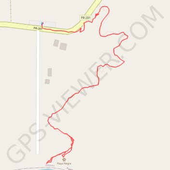
Name: Playa Negra trail, distance, elevation, map, profile, GPS track
Coordinates: 18.09592 -65.49144 18.09915 -65.48959
Topography: Vieques topographic map, elevation, terrain
Thank you for supporting this site ❤️
Make a donation
Make a donation
Gear up for your next adventure:
As an Amazon Associate, this site earns from qualifying purchases at no extra cost to you.