Thank you for supporting this site ❤️
Make a donation
Make a donation
Gear up for your next adventure:
As an Amazon Associate, this site earns from qualifying purchases at no extra cost to you.
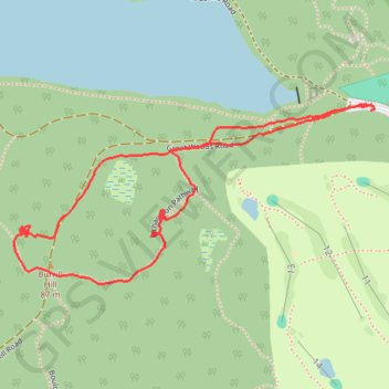
Lynn woods
- Distance: 1.5 mi
- Elevation gain: 210 ft
- Maximum elevation: 266 ft
- Elevation loss: 194 ft
- Minimum elevation: 102 ft
Interactive trail map
Thank you for supporting this site ❤️
Make a donation
Make a donation
Gear up for your next adventure:
As an Amazon Associate, this site earns from qualifying purchases at no extra cost to you.
Trail profile
- Distance: 1.5 mi
- Elevation gain: 210 ft
- Maximum elevation: 266 ft
- Elevation loss: 194 ft
- Minimum elevation: 102 ft
Thank you for supporting this site ❤️
Make a donation
Make a donation
Gear up for your next adventure:
As an Amazon Associate, this site earns from qualifying purchases at no extra cost to you.
About this trail
Name: Lynn woods trail, distance, elevation, map, profile, GPS track
Start: Great Woods Road, Lynn, Essex County, Massachusetts, 01905, United States (42.49309 -70.97750)
End: Great Woods Road, Lynn, Essex County, Massachusetts, 01905, United States (42.49297 -70.97751)
Coordinates: 42.48974 -70.98650 42.49309 -70.97744
Topography: Lynn topographic map, elevation, terrain
Thank you for supporting this site ❤️
Make a donation
Make a donation
Gear up for your next adventure:
As an Amazon Associate, this site earns from qualifying purchases at no extra cost to you.