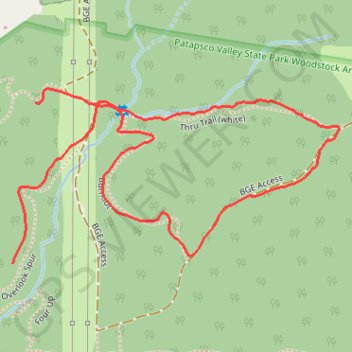
BGE Access & Thru Trail
Morning Ride
- Distance: 1.3 mi
- Elevation gain: 243 ft
- Maximum elevation: 456 ft
- Elevation loss: 164 ft
- Minimum elevation: 325 ft
- Moving time: 11 m 35 s
- Moving speed: 6.6 mph
- Maximum speed: 26.7 mph
- Total time: 14 m 9 s
- Global speed: 5.4 mph
Interactive trail map
Trail profile
- Distance: 1.3 mi
- Elevation gain: 243 ft
- Maximum elevation: 456 ft
- Elevation loss: 164 ft
- Minimum elevation: 325 ft
- Moving time: 11 m 35 s
- Moving speed: 6.6 mph
- Maximum speed: 26.7 mph
- Total time: 14 m 9 s
- Global speed: 5.4 mph
About this trail
Name: BGE Access & Thru Trail trail, distance, elevation, map, profile, GPS track
Start: Overlook Spur, Baltimore County, Maryland, 21163, United States (39.31956 -76.84310)
End: Thru Trail (white), Baltimore County, Maryland, 21163, United States (39.32238 -76.84259)
Coordinates: 39.31956 -76.84310 39.32263 -76.83571
Topography: Baltimore County topographic map, elevation, terrain
Other hiking, mountain biking, running and outdoor activity trails
Click on a trail to view its statistics, map and profile.
Patapsco Valley State Park Loop
United States > Maryland > Howard County > Ellicott City
Morning Ride
Distance: 16.6 mi • Elevation gain: 1,726 ft • Maximum elevation: 518 ft