Thank you for supporting this site ❤️
Make a donation
Make a donation
Gear up for your next adventure:
As an Amazon Associate, this site earns from qualifying purchases at no extra cost to you.
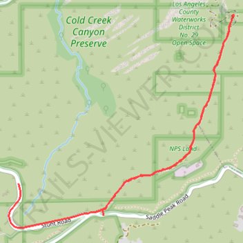
Topanga Ridge
- Distance: 2.5 mi
- Elevation gain: 410 ft
- Maximum elevation: 2,493 ft
- Elevation loss: 525 ft
- Minimum elevation: 2,218 ft
- Moving time: 1 h 7 m
- Moving speed: 2.2 mph
- Maximum speed: 37.5 mph
- Total time: 1 h 27 m
- Global speed: 1.7 mph
Interactive trail map
Thank you for supporting this site ❤️
Make a donation
Make a donation
Gear up for your next adventure:
As an Amazon Associate, this site earns from qualifying purchases at no extra cost to you.
Trail profile
- Distance: 2.5 mi
- Elevation gain: 410 ft
- Maximum elevation: 2,493 ft
- Elevation loss: 525 ft
- Minimum elevation: 2,218 ft
- Moving time: 1 h 7 m
- Moving speed: 2.2 mph
- Maximum speed: 37.5 mph
- Total time: 1 h 27 m
- Global speed: 1.7 mph
Thank you for supporting this site ❤️
Make a donation
Make a donation
Gear up for your next adventure:
As an Amazon Associate, this site earns from qualifying purchases at no extra cost to you.
About this trail
Name: Topanga Ridge trail, distance, elevation, map, profile, GPS track
Coordinates: 34.08046 -118.65092 34.09215 -118.63602
Topography: Unincorporated Santa Monica Mountains topographic map, elevation, terrain
Thank you for supporting this site ❤️
Make a donation
Make a donation
Gear up for your next adventure:
As an Amazon Associate, this site earns from qualifying purchases at no extra cost to you.