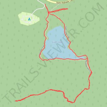
Hiking Silver Lake Trail
- Distance: 2.8 mi
- Elevation gain: 479 ft
- Maximum elevation: 10,515 ft
- Elevation loss: 489 ft
- Minimum elevation: 10,276 ft
- Moving time: 1 h 29 m
- Moving speed: 1.9 mph
- Maximum speed: 3.1 mph
- Total time: 1 h 54 m
- Global speed: 1.5 mph
Interactive trail map
Trail profile
- Distance: 2.8 mi
- Elevation gain: 479 ft
- Maximum elevation: 10,515 ft
- Elevation loss: 489 ft
- Minimum elevation: 10,276 ft
- Moving time: 1 h 29 m
- Moving speed: 1.9 mph
- Maximum speed: 3.1 mph
- Total time: 1 h 54 m
- Global speed: 1.5 mph
About this trail
Name: Hiking Silver Lake Trail trail, distance, elevation, map, profile, GPS track
Start: Silver Lake Campground Road, Carbon County, Wyoming, United States (41.31263 -106.35822)
End: Silver Lake Trail, Carbon County, Wyoming, United States (41.31242 -106.35814)
Coordinates: 41.30430 -106.36158 41.31263 -106.35300
Topography: Carbon County topographic map, elevation, terrain