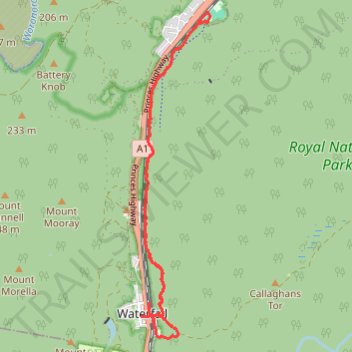
Royal National Park Ride between Waterfall and Heathcote
- Distance: 8.4 mi
- Elevation gain: 512 ft
- Maximum elevation: 774 ft
- Elevation loss: 528 ft
- Minimum elevation: 627 ft
- Moving time: 1 h 43 m
- Moving speed: 4.8 mph
- Maximum speed: 14.0 mph
- Total time: 3 h 4 m
- Global speed: 2.7 mph
Interactive trail map
Trail profile
- Distance: 8.4 mi
- Elevation gain: 512 ft
- Maximum elevation: 774 ft
- Elevation loss: 528 ft
- Minimum elevation: 627 ft
- Moving time: 1 h 43 m
- Moving speed: 4.8 mph
- Maximum speed: 14.0 mph
- Total time: 3 h 4 m
- Global speed: 2.7 mph
About this trail
Name: Royal National Park Ride between Waterfall and Heathcote trail, distance, elevation, map, profile, GPS track
Coordinates: -34.13841 150.99298 -34.09201 151.00490
Other hiking, mountain biking, running and outdoor activity trails
Click on a trail to view its statistics, map and profile.
Royal National Park Loop Ride between Heathcote and Waterfall
Australia > New South Wales > Sydney
Distance: 9.4 mi • Elevation gain: 735 ft • Maximum elevation: 810 ft
Heathcote - Miara - Depression Cave - Scouters
Australia > New South Wales > Sydney
Distance: 7.9 mi • Elevation gain: 1,414 ft • Maximum elevation: 640 ft
Waterfall Trail Run - Heathcote National Park
Australia > New South Wales > Sydney
Distance: 12.5 mi • Elevation gain: 1,709 ft • Maximum elevation: 764 ft