Thank you for supporting this site ❤️
Make a donation
Make a donation
Gear up for your next adventure:
As an Amazon Associate, this site earns from qualifying purchases at no extra cost to you.
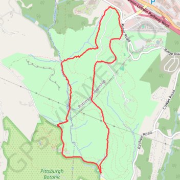
Settlers Cabin Park Loop
- Distance: 5.0 mi
- Elevation gain: 564 ft
- Maximum elevation: 1,240 ft
- Elevation loss: 571 ft
- Minimum elevation: 912 ft
- Moving time: 1 h 33 m
- Moving speed: 3.2 mph
- Maximum speed: 6.3 mph
- Total time: 1 h 33 m
- Global speed: 3.2 mph
Interactive trail map
Thank you for supporting this site ❤️
Make a donation
Make a donation
Gear up for your next adventure:
As an Amazon Associate, this site earns from qualifying purchases at no extra cost to you.
Trail profile
- Distance: 5.0 mi
- Elevation gain: 564 ft
- Maximum elevation: 1,240 ft
- Elevation loss: 571 ft
- Minimum elevation: 912 ft
- Moving time: 1 h 33 m
- Moving speed: 3.2 mph
- Maximum speed: 6.3 mph
- Total time: 1 h 33 m
- Global speed: 3.2 mph
Thank you for supporting this site ❤️
Make a donation
Make a donation
Gear up for your next adventure:
As an Amazon Associate, this site earns from qualifying purchases at no extra cost to you.
About this trail
Name: Settlers Cabin Park Loop trail, distance, elevation, map, profile, GPS track
Coordinates: 40.41341 -80.17082 40.43938 -80.15748
Topography: Allegheny County topographic map, elevation, terrain
Thank you for supporting this site ❤️
Make a donation
Make a donation
Gear up for your next adventure:
As an Amazon Associate, this site earns from qualifying purchases at no extra cost to you.