Make a donation
Gear up for your next adventure:
As an Amazon Associate, this site earns from qualifying purchases at no extra cost to you.
Gap Creek MTB circuit
- Distance: 1.6 mi
- Elevation gain: 177 ft
- Maximum elevation: 338 ft
- Elevation loss: 180 ft
- Minimum elevation: 190 ft
- Moving time: 22 m 30 s
- Moving speed: 4.2 mph
- Maximum speed: 7.2 mph
- Total time: 22 m 30 s
- Global speed: 4.2 mph
Interactive trail map
Make a donation
Gear up for your next adventure:
As an Amazon Associate, this site earns from qualifying purchases at no extra cost to you.
Trail profile
- Distance: 1.6 mi
- Elevation gain: 177 ft
- Maximum elevation: 338 ft
- Elevation loss: 180 ft
- Minimum elevation: 190 ft
- Moving time: 22 m 30 s
- Moving speed: 4.2 mph
- Maximum speed: 7.2 mph
- Total time: 22 m 30 s
- Global speed: 4.2 mph
Make a donation
Gear up for your next adventure:
As an Amazon Associate, this site earns from qualifying purchases at no extra cost to you.
About this trail
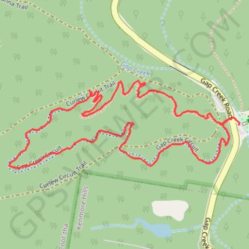
Name: Gap Creek MTB circuit trail, distance, elevation, map, profile, GPS track
Start: Gap Creek Road, Mount Coot-tha, Greater Brisbane, Queensland, 4066, Australia (-27.47855 152.92801)
Coordinates: -27.47992 152.92097 -27.47746 152.92825
Make a donation
Gear up for your next adventure:
As an Amazon Associate, this site earns from qualifying purchases at no extra cost to you.
Other hiking, mountain biking, running and outdoor activity trails
Click on a trail to view its statistics, map and profile.
Mount Coot-Tha trails
Brisbane Trail Run
Distance: 14.5 mi • Elevation gain: 2,762 ft • Maximum elevation: 856 ft
Make a donation
Gear up for your next adventure:
As an Amazon Associate, this site earns from qualifying purchases at no extra cost to you.