Duck Lake, Barney Lake, Skelton Lake and Arrowhead Lake via Duck Pass Trail
The Duck Pass Trail in the Inyo National Forest is a favorite for hiking enthusiasts, offering breathtaking views and access to pristine alpine lakes such as Skelton Lake, Barney Lake, and the expansive Duck Lake. The trail begins in a shaded forest with steady climbs and switchbacks, opening up to serene lakes and dramatic vistas of granite peaks and lush meadows. As you traverse the route, each lake presents its unique charm, from the reflective stillness of Arrowhead Lake to the deep blues of Duck Lake, making it a rewarding journey for those seeking a connection with nature's tranquility and grandeur. #Hiking #Mountain #Forest #Nature #Lake
- Distance: 5.6 mi
- Elevation gain: 1,919 ft
- Maximum elevation: 10,774 ft
- Elevation loss: 846 ft
- Minimum elevation: 9,114 ft
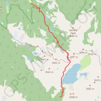
Interactive trail map
Trail profile
- Distance: 5.6 mi
- Elevation gain: 1,919 ft
- Maximum elevation: 10,774 ft
- Elevation loss: 846 ft
- Minimum elevation: 9,114 ft
About this trail
Name: Duck Lake, Barney Lake, Skelton Lake and Arrowhead Lake via Duck Pass Trail trail, distance, elevation, map, profile, GPS track
Start: Emerald Lake Trail, Mammoth Lakes, Mono County, California, United States (37.59119 -118.99068)
End: John Muir Trail, Fresno County, California, United States (37.53802 -118.96957)
Coordinates: 37.53802 -118.99072 37.59130 -118.96215
Topography: Mono County topographic map, elevation, terrain