Thank you for supporting this site ❤️
Make a donation
Make a donation
Gear up for your next adventure:
As an Amazon Associate, this site earns from qualifying purchases at no extra cost to you.
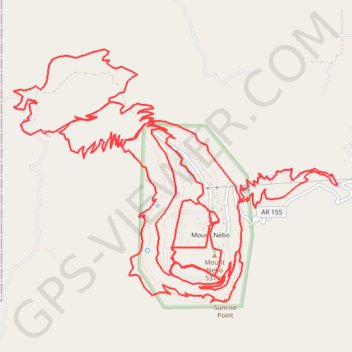
Mount Nebo State Park Trails
- Distance: 26.3 mi
- Elevation gain: 4,442 ft
- Maximum elevation: 1,785 ft
- Elevation loss: 4,446 ft
- Minimum elevation: 676 ft
- Moving time: 3 h 24 m
- Moving speed: 7.7 mph
- Maximum speed: 22.6 mph
- Total time: 3 h 45 m
- Global speed: 7.0 mph
Interactive trail map
Thank you for supporting this site ❤️
Make a donation
Make a donation
Gear up for your next adventure:
As an Amazon Associate, this site earns from qualifying purchases at no extra cost to you.
Trail profile
- Distance: 26.3 mi
- Elevation gain: 4,442 ft
- Maximum elevation: 1,785 ft
- Elevation loss: 4,446 ft
- Minimum elevation: 676 ft
- Moving time: 3 h 24 m
- Moving speed: 7.7 mph
- Maximum speed: 22.6 mph
- Total time: 3 h 45 m
- Global speed: 7.0 mph
Thank you for supporting this site ❤️
Make a donation
Make a donation
Gear up for your next adventure:
As an Amazon Associate, this site earns from qualifying purchases at no extra cost to you.
About this trail
Name: Mount Nebo State Park Trails trail, distance, elevation, map, profile, GPS track
Start: County Road 134, Mount Nebo, Yell County, Arkansas, United States (35.22028 -93.25130)
End: County Road 134, Mount Nebo, Yell County, Arkansas, United States (35.22043 -93.25118)
Coordinates: 35.21162 -93.27835 35.23891 -93.23547
Topography: Yell County topographic map, elevation, terrain
Thank you for supporting this site ❤️
Make a donation
Make a donation
Gear up for your next adventure:
As an Amazon Associate, this site earns from qualifying purchases at no extra cost to you.