Hidden Lake Overlook via Hidden Lake Trail in Glacier National Park
The Hidden Lake Trail is a stunning, short hike that offers a rewarding mix of alpine scenery and wildlife. The trail starts at Logan Pass, winding through breathtaking meadows known as the Hanging Gardens, where you'll be treated to wildflowers in the summer and the sight of towering peaks like Bearhat Mountain. Keep an eye out for mountain goats and marmots as you hike along boardwalks and across streams. The panoramic views of Hidden Lake are simply unforgettable, making this a top hike for anyone visiting the park, although it can get crowded, so arriving early is key for a more peaceful experience. #Hiking #Mountain #Lake #Nature
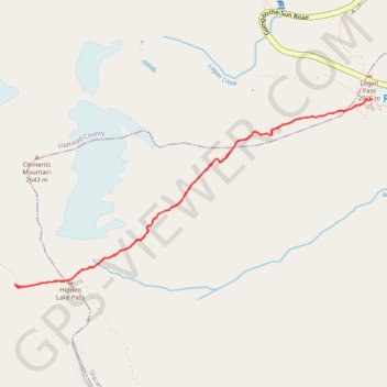
- Distance: 2.8 mi
- Elevation gain: 577 ft
- Maximum elevation: 7,172 ft
- Elevation loss: 577 ft
- Minimum elevation: 6,654 ft
- Moving time: 1 h 11 m
- Moving speed: 2.3 mph
- Maximum speed: 3.4 mph
- Total time: 1 h 26 m
- Global speed: 1.9 mph
Interactive trail map
Trail profile
- Distance: 2.8 mi
- Elevation gain: 577 ft
- Maximum elevation: 7,172 ft
- Elevation loss: 577 ft
- Minimum elevation: 6,654 ft
- Moving time: 1 h 11 m
- Moving speed: 2.3 mph
- Maximum speed: 3.4 mph
- Total time: 1 h 26 m
- Global speed: 1.9 mph
About this trail
Name: Hidden Lake Overlook via Hidden Lake Trail in Glacier National Park trail, distance, elevation, map, profile, GPS track
Start: Going-to-the-Sun Road, Glacier County, Montana, United States (48.69561 -113.71765)
End: Going-to-the-Sun Road, Glacier County, Montana, United States (48.69561 -113.71770)
Coordinates: 48.68720 -113.74187 48.69563 -113.71765
Topography: Glacier County topographic map, elevation, terrain
Other hiking, mountain biking, running and outdoor activity trails
Click on a trail to view its statistics, map and profile.
Hidden Lake Overlook via Hidden Lake Trail in Glacier National Park
United States > Montana > Glacier County
The Hidden Lake Overlook Trail offers an accessible yet rewarding hiking experience in Glacier National Park, providing sweeping views of alpine meadows and rugged mountain peaks. The route begins at Logan Pass and meanders through the iconic Hanging Gardens, where vibrant wildflowers bloom in summer, with…
Distance: 2.7 mi • Elevation gain: 568 ft • Maximum elevation: 7,172 ft
Highline Trail in Glacier National Park
United States > Montana > Glacier County
The Highline Trail is an enchanting journey that showcases the breathtaking beauty of nature! As you traverse the trail, you'll be treated to stunning panoramic views of towering peaks like Mount Reynolds and the Garden Wall, vibrant wildflowers, and perhaps even a glimpse of playful mountain goats or chirping…
Distance: 15.6 mi • Elevation gain: 4,144 ft • Maximum elevation: 7,287 ft
Highline Trail and Granite Park Trail in Glacier National Park
United States > Montana > Glacier County
The Highline Trail in Glacier National Park is a premier hiking route known for its stunning vistas along the Garden Wall, offering sweeping views of rugged peaks and deep valleys. Wildlife such as mountain goats and marmots often make appearances, adding to the trail’s allure. The Granite Park Chalet serves…
Distance: 11.9 mi • Elevation gain: 2,156 ft • Maximum elevation: 7,300 ft
Hidden Lake via Hidden Lake Overlook in Galcier National Park
United States > Montana > Glacier County
The hike to Hidden Lake is a delightful adventure filled with breathtaking scenery and abundant wildlife! As you trek through lush meadows adorned with wildflowers, you'll be treated to panoramic views of majestic peaks, including the iconic Bearhat Mountain and the sparkling Hidden Lake below. Keep your eyes…
Distance: 5.7 mi • Elevation gain: 1,470 ft • Maximum elevation: 7,182 ft
Hidden Lake Trail in Glacier National Park
United States > Montana > Glacier County
The Hidden Lake Trail offers a rewarding hike with breathtaking views across Glacier National Park, starting at Logan Pass. Along the way, hikers are treated to sweeping vistas of towering peaks like Bearhat Mountain and Clements Mountain, as well as lush alpine meadows dotted with wildflowers during the…
Distance: 5.2 mi • Elevation gain: 1,385 ft • Maximum elevation: 7,178 ft