Thank you for supporting this site ❤️
Make a donation
Make a donation
Gear up for your next adventure:
As an Amazon Associate, this site earns from qualifying purchases at no extra cost to you.
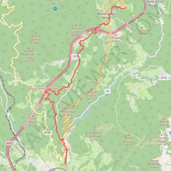
Via Francigena, Toscana var Montelungo-Pontremoli
- Distance: 8.2 mi
- Elevation gain: 699 ft
- Maximum elevation: 3,176 ft
- Elevation loss: 3,045 ft
- Minimum elevation: 823 ft
Interactive trail map
Thank you for supporting this site ❤️
Make a donation
Make a donation
Gear up for your next adventure:
As an Amazon Associate, this site earns from qualifying purchases at no extra cost to you.
Trail profile
- Distance: 8.2 mi
- Elevation gain: 699 ft
- Maximum elevation: 3,176 ft
- Elevation loss: 3,045 ft
- Minimum elevation: 823 ft
Thank you for supporting this site ❤️
Make a donation
Make a donation
Gear up for your next adventure:
As an Amazon Associate, this site earns from qualifying purchases at no extra cost to you.
About this trail
Name: Via Francigena, Toscana var Montelungo-Pontremoli trail, distance, elevation, map, profile, GPS track
Coordinates: 44.38327 9.87140 44.45101 9.91991
Thank you for supporting this site ❤️
Make a donation
Make a donation
Gear up for your next adventure:
As an Amazon Associate, this site earns from qualifying purchases at no extra cost to you.
Other hiking, mountain biking, running and outdoor activity trails
Click on a trail to view its statistics, map and profile.
1 LUCENA - MONTPELLIER
Distance: 1,842.0 mi • Elevation gain: 96,785 ft • Maximum elevation: 3,438 ft