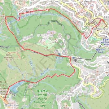
Central Hong Kong - Pok Fu Lam Country Park
- Distance: 4.6 mi
- Elevation gain: 1,414 ft
- Maximum elevation: 1,316 ft
- Elevation loss: 1,155 ft
- Minimum elevation: 200 ft
Interactive trail map
Trail profile
About this trail
Name: Central Hong Kong - Pok Fu Lam Country Park trail, distance, elevation, map, profile, GPS track
Coordinates: 22.26261 114.13528 22.28089 114.15692
Other hiking, mountain biking, running and outdoor activity trails
Click on a trail to view its statistics, map and profile.
HK dino
China > Hong Kong > Hong Kong Island
Loop hike from Kennedy Town via Lung Fu Shan, High West, Victoria Peak, Pok Fu Lam Reservoir and Mount Davis in the Lung Fu Shan Country Park and the Pok Fu Lam Country Park. #Hiking #Loop #Nature #Mountain #Forest #Sea #Pacific #Ocean #Park
Distance: 15.2 mi • Elevation gain: 4,347 ft • Maximum elevation: 1,736 ft
Hong Kong island ride
China > Hong Kong > Hong Kong Island
#Bike
Distance: 38.4 mi • Elevation gain: 7,060 ft • Maximum elevation: 1,657 ft
薑花石澗右源 奇薄坑 薄扶林東坑
China > Hong Kong > Hong Kong Island
Hong Kong Island Hike
Distance: 3.4 mi • Elevation gain: 853 ft • Maximum elevation: 1,407 ft
荷兰径
China > Hong Kong > Hong Kong Island
Outdoor walk
Distance: 5.3 mi • Elevation gain: 2,356 ft • Maximum elevation: 1,093 ft
Wilson Trail Full Route
China > Hong Kong > Hong Kong Island
Distance: 50.5 mi • Elevation gain: 14,534 ft • Maximum elevation: 2,011 ft
Trail Planner Map
China > Hong Kong > Hong Kong Island
Distance: 12.6 mi • Elevation gain: 3,776 ft • Maximum elevation: 1,388 ft