Thank you for supporting this site ❤️
Make a donation
Make a donation
Gear up for your next adventure:
As an Amazon Associate, this site earns from qualifying purchases at no extra cost to you.
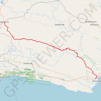
Willowmore - Jeffreys Bay
#Bike
- Distance: 140.3 mi
- Elevation gain: 11,732 ft
- Maximum elevation: 3,793 ft
- Elevation loss: 14,124 ft
- Minimum elevation: 33 ft
Interactive trail map
Thank you for supporting this site ❤️
Make a donation
Make a donation
Gear up for your next adventure:
As an Amazon Associate, this site earns from qualifying purchases at no extra cost to you.
Trail profile
- Distance: 140.3 mi
- Elevation gain: 11,732 ft
- Maximum elevation: 3,793 ft
- Elevation loss: 14,124 ft
- Minimum elevation: 33 ft
Thank you for supporting this site ❤️
Make a donation
Make a donation
Gear up for your next adventure:
As an Amazon Associate, this site earns from qualifying purchases at no extra cost to you.
About this trail
Name: Willowmore - Jeffreys Bay trail, distance, elevation, map, profile, GPS track
Coordinates: -34.03125 23.48699 -33.29384 24.92408
Thank you for supporting this site ❤️
Make a donation
Make a donation
Gear up for your next adventure:
As an Amazon Associate, this site earns from qualifying purchases at no extra cost to you.
Other hiking, mountain biking, running and outdoor activity trails
Click on a trail to view its statistics, map and profile.