Import a GPX file

Wungong Gorge

#Hiking #Loop

  • Distance: 9.3 mi
  • Elevation gain: 2,037 ft
  • Maximum elevation: 866 ft
  • Elevation loss: 2,037 ft
  • Minimum elevation: 187 ft

Interactive trail map

Trail profile

  • Distance: 9.3 mi
  • Elevation gain: 2,037 ft
  • Maximum elevation: 866 ft
  • Elevation loss: 2,037 ft
  • Minimum elevation: 187 ft

About this trail
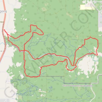
Name: Wungong Gorge trail, distance, elevation, map, profile, GPS track

Start: Rails Crescent, Wungong, City Of Armadale, Western Australia, 6122, Australia (-32.18928 116.01574)

End: Rails Crescent, Wungong, City Of Armadale, Western Australia, 6122, Australia (-32.18928 116.01574)

Coordinates: -32.20542 116.01574 -32.18756 116.05385

Gear up for your next adventure:

🗺️Topographic Maps - Detailed topo maps for hiking, exploring and outdoor navigation
🪑Ultralight Camp Chairs - Portable seating for resting after a long day of mapping
🌡️Handheld Weather Meters - Measure wind, temp, and pressure for safe mountain travel
👟Men's Trail Runners - Lightweight footwear for fast-paced exploration and light hiking
🎒Trail Energy Bars - High‑calorie bars for hiking energy

As an Amazon Associate, this site earns from qualifying purchases at no extra cost to you.