Make a donation
Gear up for your next adventure:
As an Amazon Associate, this site earns from qualifying purchases at no extra cost to you.
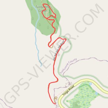
Tuolumne Grove Loop
Loop hike to Tuolumne Grove via Old Big Oak Road, Tunnel Tree and Viewpoint for Giant Sequoias in the Yosemite National Park. #Hiking #Loop #Forest #Park #Nature #Yosemite
- Distance: 2.8 mi
- Elevation gain: 617 ft
- Maximum elevation: 6,214 ft
- Elevation loss: 617 ft
- Minimum elevation: 5,696 ft
- Moving time: 1 h 40 m
- Moving speed: 1.7 mph
- Maximum speed: 4.1 mph
- Total time: 1 h 46 m
- Global speed: 1.6 mph
Interactive trail map
Make a donation
Gear up for your next adventure:
As an Amazon Associate, this site earns from qualifying purchases at no extra cost to you.
Trail profile
- Distance: 2.8 mi
- Elevation gain: 617 ft
- Maximum elevation: 6,214 ft
- Elevation loss: 617 ft
- Minimum elevation: 5,696 ft
- Moving time: 1 h 40 m
- Moving speed: 1.7 mph
- Maximum speed: 4.1 mph
- Total time: 1 h 46 m
- Global speed: 1.6 mph
Make a donation
Gear up for your next adventure:
As an Amazon Associate, this site earns from qualifying purchases at no extra cost to you.
About this trail
Name: Tuolumne Grove Loop trail, distance, elevation, map, profile, GPS track
Start: Tioga Road, Mariposa County, California, United States (37.75824 -119.80552)
End: Tioga Road, Mariposa County, California, United States (37.75824 -119.80552)
Coordinates: 37.75824 -119.80763 37.77048 -119.80391
Topography: Mariposa County topographic map, elevation, terrain
Make a donation
Gear up for your next adventure:
As an Amazon Associate, this site earns from qualifying purchases at no extra cost to you.