Make a donation
Gear up for your next adventure:
As an Amazon Associate, this site earns from qualifying purchases at no extra cost to you.
Kirkwood Meadows
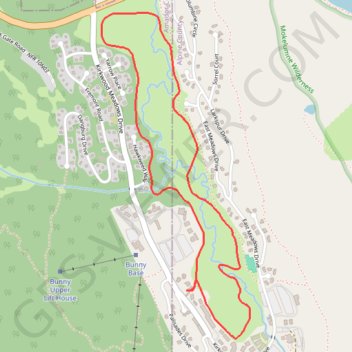
Interactive trail map
Make a donation
Gear up for your next adventure:
As an Amazon Associate, this site earns from qualifying purchases at no extra cost to you.
Trail profile
- Distance: 3.0 mi
- Elevation gain: 217 ft
- Maximum elevation: 7,815 ft
- Elevation loss: 217 ft
- Minimum elevation: 7,700 ft
Make a donation
Gear up for your next adventure:
As an Amazon Associate, this site earns from qualifying purchases at no extra cost to you.
About this trail
Name: Kirkwood Meadows trail, distance, elevation, map, profile, GPS track
Start: 830, Kirkwood Meadows Drive, Alpine County, California, 95646, United States (38.68705 -120.07157)
End: 836, Kirkwood Meadows Drive, Alpine County, California, 95646, United States (38.68706 -120.07155)
Coordinates: 38.68473 -120.07686 38.70055 -120.06761
Topography: Alpine County topographic map, elevation, terrain
Make a donation
Gear up for your next adventure:
As an Amazon Associate, this site earns from qualifying purchases at no extra cost to you.