Make a donation
Gear up for your next adventure:
As an Amazon Associate, this site earns from qualifying purchases at no extra cost to you.
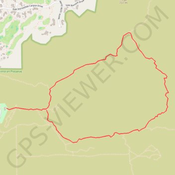
McDowell Sonoran Preserve
Interactive trail map
Make a donation
Gear up for your next adventure:
As an Amazon Associate, this site earns from qualifying purchases at no extra cost to you.
Trail profile
- Distance: 3.9 mi
- Elevation gain: 758 ft
- Maximum elevation: 2,388 ft
- Elevation loss: 692 ft
- Minimum elevation: 1,726 ft
Make a donation
Gear up for your next adventure:
As an Amazon Associate, this site earns from qualifying purchases at no extra cost to you.
About this trail
Name: McDowell Sonoran Preserve trail, distance, elevation, map, profile, GPS track
Start: Saguaro Trail, Scottsdale, Maricopa County, Arizona, 85255, United States (33.64939 -111.85822)
End: Gateway Loop Trail, Scottsdale, Maricopa County, Arizona, 85060, United States (33.64914 -111.85209)
Coordinates: 33.64501 -111.85822 33.65909 -111.83331
Topography: Scottsdale topographic map, elevation, terrain
Make a donation
Gear up for your next adventure:
As an Amazon Associate, this site earns from qualifying purchases at no extra cost to you.
Other hiking, mountain biking, running and outdoor activity trails
Click on a trail to view its statistics, map and profile.