Thank you for supporting this site ❤️
Make a donation
Make a donation
Gear up for your next adventure:
As an Amazon Associate, this site earns from qualifying purchases at no extra cost to you.
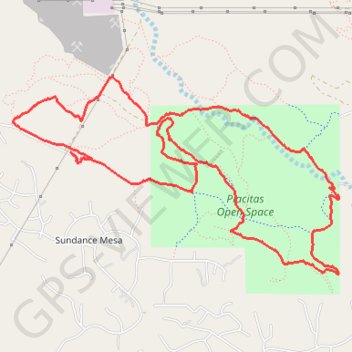
Placitas Open Space Loop
Loop hike / run / trail through Placitas Open Space. #Hiking #Running #Trail #Loop #Nature
- Distance: 6.9 mi
- Elevation gain: 617 ft
- Maximum elevation: 5,623 ft
- Elevation loss: 620 ft
- Minimum elevation: 5,292 ft
- Moving time: 1 h 17 m
- Moving speed: 5.3 mph
- Maximum speed: 23.5 mph
- Total time: 1 h 37 m
- Global speed: 4.2 mph
Interactive trail map
Thank you for supporting this site ❤️
Make a donation
Make a donation
Gear up for your next adventure:
As an Amazon Associate, this site earns from qualifying purchases at no extra cost to you.
Trail profile
- Distance: 6.9 mi
- Elevation gain: 617 ft
- Maximum elevation: 5,623 ft
- Elevation loss: 620 ft
- Minimum elevation: 5,292 ft
- Moving time: 1 h 17 m
- Moving speed: 5.3 mph
- Maximum speed: 23.5 mph
- Total time: 1 h 37 m
- Global speed: 4.2 mph
Thank you for supporting this site ❤️
Make a donation
Make a donation
Gear up for your next adventure:
As an Amazon Associate, this site earns from qualifying purchases at no extra cost to you.
About this trail
Name: Placitas Open Space Loop trail, distance, elevation, map, profile, GPS track
Coordinates: 35.32762 -106.49103 35.34277 -106.46038
Topography: Sandoval County topographic map, elevation, terrain
Thank you for supporting this site ❤️
Make a donation
Make a donation
Gear up for your next adventure:
As an Amazon Associate, this site earns from qualifying purchases at no extra cost to you.