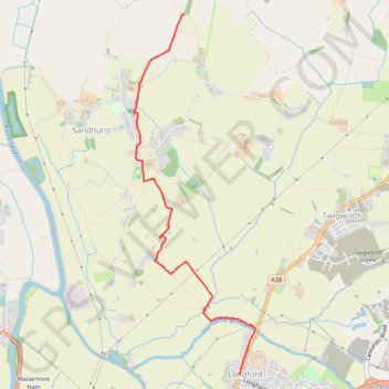
Public footpath explore
- Distance: 3.2 mi
- Elevation gain: 135 ft
- Maximum elevation: 121 ft
- Elevation loss: 56 ft
- Minimum elevation: 26 ft
- Moving time: 1 h 17 m
- Moving speed: 2.4 mph
- Maximum speed: 3.7 mph
- Total time: 1 h 26 m
- Global speed: 2.2 mph
Interactive trail map
Trail profile
- Distance: 3.2 mi
- Elevation gain: 135 ft
- Maximum elevation: 121 ft
- Elevation loss: 56 ft
- Minimum elevation: 26 ft
- Moving time: 1 h 17 m
- Moving speed: 2.4 mph
- Maximum speed: 3.7 mph
- Total time: 1 h 26 m
- Global speed: 2.2 mph
About this trail
Name: Public footpath explore trail, distance, elevation, map, profile, GPS track
Coordinates: 51.88559 -2.25092 51.91648 -2.23396
Other hiking, mountain biking, running and outdoor activity trails
Click on a trail to view its statistics, map and profile.
Dean2023-311
United Kingdom > England > Oxfordshire > Oxford
Distance: 192.8 mi • Elevation gain: 11,043 ft • Maximum elevation: 951 ft