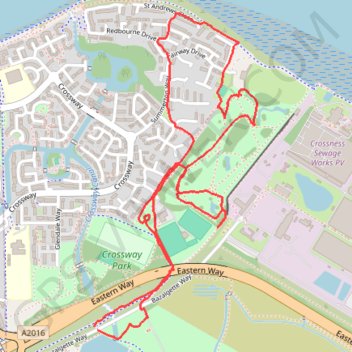
Crossway Park ex golf course
Lunch Walk
- Distance: 2.9 mi
- Elevation gain: 79 ft
- Maximum elevation: 26 ft
- Elevation loss: 82 ft
- Minimum elevation: 0 ft
- Moving time: 57 m 4 s
- Moving speed: 3.0 mph
- Maximum speed: 4.6 mph
- Total time: 1 h 2 m
- Global speed: 2.8 mph
Interactive trail map
Trail profile
- Distance: 2.9 mi
- Elevation gain: 79 ft
- Maximum elevation: 26 ft
- Elevation loss: 82 ft
- Minimum elevation: 0 ft
- Moving time: 57 m 4 s
- Moving speed: 3.0 mph
- Maximum speed: 4.6 mph
- Total time: 1 h 2 m
- Global speed: 2.8 mph
About this trail
Name: Crossway Park ex golf course trail, distance, elevation, map, profile, GPS track
Coordinates: 51.50171 0.12561 51.51246 0.13424
Other hiking, mountain biking, running and outdoor activity trails
Click on a trail to view its statistics, map and profile.
Crossway Park
United Kingdom > England > London
Morning Run
Distance: 6.0 mi • Elevation gain: 125 ft • Maximum elevation: 72 ft
Crossway Park
United Kingdom > England > London
Morning Run
Distance: 5.9 mi • Elevation gain: 121 ft • Maximum elevation: 75 ft
Thamesmead
United Kingdom > England > London
Lunch Walk
Distance: 5.9 mi • Elevation gain: 282 ft • Maximum elevation: 220 ft