Make a donation
Gear up for your next adventure:
As an Amazon Associate, this site earns from qualifying purchases at no extra cost to you.
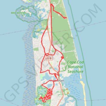
GravelBike CapeCod
Afternoon Ride
- Distance: 35.2 mi
- Elevation gain: 830 ft
- Maximum elevation: 62 ft
- Elevation loss: 827 ft
- Minimum elevation: 7 ft
- Moving time: 2 h 48 m
- Moving speed: 12.6 mph
- Maximum speed: 25.8 mph
- Total time: 2 h 48 m
- Global speed: 12.6 mph
Interactive trail map
Make a donation
Gear up for your next adventure:
As an Amazon Associate, this site earns from qualifying purchases at no extra cost to you.
Trail profile
- Distance: 35.2 mi
- Elevation gain: 830 ft
- Maximum elevation: 62 ft
- Elevation loss: 827 ft
- Minimum elevation: 7 ft
- Moving time: 2 h 48 m
- Moving speed: 12.6 mph
- Maximum speed: 25.8 mph
- Total time: 2 h 48 m
- Global speed: 12.6 mph
Make a donation
Gear up for your next adventure:
As an Amazon Associate, this site earns from qualifying purchases at no extra cost to you.
About this trail
Name: GravelBike CapeCod trail, distance, elevation, map, profile, GPS track
Start: 240, Mill Road, Eastham, Barnstable County, Massachusetts, 02642, United States (41.83317 -69.97749)
End: 205, Mill Road, Eastham, Barnstable County, Massachusetts, 02642, United States (41.83335 -69.97772)
Coordinates: 41.80914 -69.99928 41.90476 -69.96354
Topography: Barnstable County topographic map, elevation, terrain
Make a donation
Gear up for your next adventure:
As an Amazon Associate, this site earns from qualifying purchases at no extra cost to you.
Other hiking, mountain biking, running and outdoor activity trails
Click on a trail to view its statistics, map and profile.
Cape Cod Fire Roads
United States > Massachusetts > Barnstable County > Eastham
Cape Cod National Seashore
Distance: 60.7 mi • Elevation gain: 2,608 ft • Maximum elevation: 118 ft
Wandering Eastham
United States > Massachusetts > Barnstable County > Eastham
Distance: 12.5 mi • Elevation gain: 295 ft • Maximum elevation: 46 ft