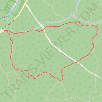
Reeves Brook Loop Trail
Interactive trail map
Trail profile
- Distance: 3.7 mi
- Elevation gain: 820 ft
- Maximum elevation: 1,184 ft
- Elevation loss: 823 ft
- Minimum elevation: 446 ft
- Moving time: 2 h 5 m
- Moving speed: 1.8 mph
- Maximum speed: 3.7 mph
- Total time: 2 h 53 m
- Global speed: 1.3 mph
About this trail
Name: Reeves Brook Loop Trail trail, distance, elevation, map, profile, GPS track
Coordinates: 41.16482 -74.16829 41.17549 -74.14564
Topography: Rockland County topographic map, elevation, terrain
Other hiking, mountain biking, running and outdoor activity trails
Click on a trail to view its statistics, map and profile.
Reeves Brook Loop via Seven Hills Trail and Pine Meadow Trail in Harriman State Park
United States > New York > Rockland County > Village of Sloatsburg
The Reeves Brook Loop Trail in Harriman State Park offers hikers a diverse experience, featuring streams, small waterfalls, and rock scrambles. Along the route, one can enjoy panoramic vistas from various overlooks and traverse through vibrant woodlands, while the varied terrain—including steep ascents and…
Distance: 3.7 mi • Elevation gain: 804 ft • Maximum elevation: 1,181 ft