Make a donation
Gear up for your next adventure:
As an Amazon Associate, this site earns from qualifying purchases at no extra cost to you.
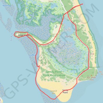
Sandy Point Loop, Newbury / Plum Island, MA
- Distance: 3.6 mi
- Elevation gain: 85 ft
- Maximum elevation: 23 ft
- Elevation loss: 85 ft
- Minimum elevation: -3 ft
- Moving time: 1 h 34 m
- Moving speed: 2.3 mph
- Maximum speed: 3.3 mph
- Total time: 1 h 43 m
- Global speed: 2.1 mph
Interactive trail map
Make a donation
Gear up for your next adventure:
As an Amazon Associate, this site earns from qualifying purchases at no extra cost to you.
Trail profile
- Distance: 3.6 mi
- Elevation gain: 85 ft
- Maximum elevation: 23 ft
- Elevation loss: 85 ft
- Minimum elevation: -3 ft
- Moving time: 1 h 34 m
- Moving speed: 2.3 mph
- Maximum speed: 3.3 mph
- Total time: 1 h 43 m
- Global speed: 2.1 mph
Make a donation
Gear up for your next adventure:
As an Amazon Associate, this site earns from qualifying purchases at no extra cost to you.
About this trail
Name: Sandy Point Loop, Newbury / Plum Island, MA trail, distance, elevation, map, profile, GPS track
Start: Lot 6 Boardwalk, Ipswich, Essex County, Massachusetts, United States (42.71392 -70.77785)
End: Lot 6 Boardwalk, Ipswich, Essex County, Massachusetts, United States (42.71388 -70.77786)
Coordinates: 42.70017 -70.78930 42.71526 -70.77317
Topography: Essex County topographic map, elevation, terrain
Make a donation
Gear up for your next adventure:
As an Amazon Associate, this site earns from qualifying purchases at no extra cost to you.